Wednesday, June 22, 2011

RTTMS June 21, 2011 To the Mountains

Bright, clear blue skies greeted us this morning when we got up. Dry riding once again!!!

Jeff and I loaded up in Grande Prairie, AB., and headed south on Highway 40 toward the Canadian Rockies in Jasper, Banff and Kootenay National Parks.
The route south passed through large forests used for logging and we passed a couple of very large lumber mills that make plywood, oriented strand board and medium density fiberboard.

The road was in good shape and provided wonderful views of the valleys, rivers and high ridges that cover this area. Not a lot of development with the exception of natural gas wells and pumping locations. It seems they have figured out a way not to screw up the local land to do the well drilling and collection of the gas.
We found a little wildlife while on the road with deer showing up once and a while. No moose, elk, sheep or bison.

We passed a large coal fired power plant next to a river and the coal mining operation was just across the highway. This was along Sheep Creek which was very fast flowing and didn't look like it was being polluted but the power plant. We could see the veins of coal in the side of the mountain.
We stopped at Grande Cache which is located on a high plateau with a wonderful view of the snow covered mountains to the south....the way we were going.
The further south we traveled, the mountains grew larger and more numerous in our windshields.

We quickly entered Jasper National Park and were treated to some of the most fantastic view of shear walled, snow capped mountains on all sides. Words are hard to use to describe the variety of sights before our eves. I will let some of these pictures tell part of the story.
We stopped several times to get better views of some of the peaks and valleys. Again, I will let the pictures talk. Even though a picture is worth a thousand words, these pictures do not begin to tell of the grandeur.
Aren't the views spectacular!!!! And more to come.

Jeff then had a mechanical problem and we stopped to adjust his chain. Not a big deal and we were quickly on our way.
The wonderful views continued.
This is called the Weeping Wall because of all of the waterfalls.

I could continue on for a long time but I think you get the idea about the views. The roads were terrific also.

We quickly passed out of the parks and into Radium Hot Springs. You have to pass through a large slot in the canyon. Kinda neat.
The motel was OK but the Internet connection was terrible and that is why I am completing this entry today.

Rode about 416 miles today, or 670 km.

More tomorrow.

Mike

Monday, June 20, 2011

RTTMS June 20, 2011 Rain Part 2

Once again the rain was part of our riding day. Since we seemed to handle the rain OK yesterday, today the weather gods added fog and lots of it. About 100 miles of fog. Cold, wet, thick, chunky fog. This made for very slow going at the beginning of the day but that is part of motorcycle riding.

I am pointing at my clothes drying system that is being used since my clothes did not make it to me before I left Alaska. I wash the clothes at night and then put them in this net bag and then they get air dried while riding.....except when it rains like today.
The ride south from Fort Nelson, BC., went well considering the fog with some rain mixed in for good measure. We had to cut our road speed to ensure being safe so progress was somewhat slow but we continued onward.
To add more fun to the ride, the road has a lot of mud, gravel and dirt from the vehicles entering from the side roads so when we passed an oncoming vehicle, especially a large semi (and these up here have up to 8 axles ) there is a huge cloud of brown spray with stones added for excitement that we have to contend with. More fun in Canada.

I noticed that beginning just south of Fort St. John, farms started to appear. There are large areas of crops being grown and the soil tilled for planting. I guess that the permafrost and soil conditions are more favorable here then just a few miles north. Also, the fog disappeared and the rain just about quit so we could see more of our surroundings instead of concentrating on the road.
Just south of Fort St. John we had to cross another steel grate bridge....I just love these things.
Just south of the bridge is part of the original Alaska Highway including the a wooden curved bridge. This has been saved as a historical site. It is pretty neat and you can drive across the bridge.
We then passed through Dawson Creek, BC., the beginning of the Alaska Highway. To the south and east we saw more rain clouds but we missed the rain.
We then quickly arrived at our destination in Grande Prairie, Alberta, for the evening.

A short 364 miles today in spite of the weather.

Tomorrow we are going to Banff and Jasper National Park while heading to the USA. From there, we are going to Great Falls, MT., and then head east. Me to my brother's home in Brookfield, Wisconsin, and Jeff, getting on I-29 South toward the Tennessee area and then home to Florida.

The ride continues. Hopefully without rain or fog....but more scenery.

Mike

Sunday, June 19, 2011

RTTMS June 19, 2011 Happy Fathers Day in The Rain

Happy Fathers Day to all the Dads reading this blog. I have a special Fathers Day wishes for my two sons that are Fathers, Scott and Jason. I hope you had a Great Day. You deserve it.

We arose this morning in Whitehorse, YT., to the sound of dripping rain outside our room. It seems that it rained most of the night and as it turned out, most of our riding day.

Most motorcycle riders do not mind riding in the rain if the get caught in it but starting out in it is a lot less fun. We loaded our stuff, got some fuel at the second place we stopped because a lot of businesses do not open before 8 am around here. Takes a little getting used to.

We hit the Alaska Highway going south toward British Columbia with our goal being Ft. Nelson for the evening. We planned to stop at the Teslin Bridge to refuel and get some breakfast before we attacked the l-o-n-g steel grate bridge once again. Of course, we did not really like the addition of wet to the grate bridge crossing. Since there is not another road to take, the bridge crossing was going to happen.

We stopped as planned and the rain had not been very bad. It was more like drizzle and stop, drizzle and stop, so the road being wet was our main problem. The temperature was 48 degrees F or 9 degrees C.

Breakfast went well and then we attacked the bridge. Steady throttle and light grip on the handlebars......easy does it. Hold your breath...we are across!!! When I completed crossing, I let out my breath and my face shield fogged up and I couldn't see for a few seconds. Great. Make the bridge and hit something on the other side.

No pictures on this part since my camera is not waterproof. Maybe next time.

The gravel road repairs that we encountered on the way up were actually much easier now since traffic had packed the loose gravel a great deal and the water eliminated the dust problem. Maybe rain isn't so bad after all.

We quickly crossed into British Columbia and felt better because the roads are in better condition and the riding was easier. Still with light rain, mist, low clouds and wet roads.

As we were approaching our next refuel stop at Coal River, we passed three women ride their bikes. They stopped at the same place we did and they were on their way to the Liard Hot Springs for the day. How do you pronounce Liard? Answer later.

We headed out and suddenly, it seemed that we had entered a zoo. We saw Black Bears, Stone Sheep, Bison, Bald Eagles and Coyotes. Didn't get pictures of the Eagles or Coyotes but here are pictures of the rest.

The Bison
Crossing the Road
The Stone Sheep
Two Bears
The rain quit for awhile and we were able to make some good time in the mountains. A picture of us chasing a big fuel tanker in the mountains....he was really fast.
Chasing Jeff through the twisties....lots of fun when it is dry!!! Notice the lack of guard rails!!
The weather cleared up for a while so we were able to make good time but then as we neared Ft. Nelson, it closed in again and it was raining when we unloaded at the hotel.

Road 960 kilometers or 584 miles. Tired and not too wet. Long Fathers Day.

Liard is pronounced Lay Aired. At least in this area of Canada.

Going to Grande Praire, Alberta, tomorrow. Kinda a short ride.

Done for today,

Mike

Saturday, June 18, 2011

RTTMS June 18, 2011 Headin' South-Sort of

Today we arose in Tok,Ak at about 5:00 am and started loading to make a quick exit to Whitehorse, YT., after breakfast. Question...how to you pronounce TOK?

The weather was cool, about 46 degrees F, clear blue sky and no wind. We were quickly on the highway looking forward to crossing into the Yukon Territory and making the turn south.
The road has some wet spots on it from the rain yesterday but other than that, it was clear riding. We passed several scenic views that we had missed on the way north. Sometimes traveling the opposite direction on a road yields a very different sights.

The valley leading to the border is very lush and covered with lakes, streams and sitka spruce trees. Once again, the tall mountains that filled the horizon were capped with bright white snow and cloud cover.
We passed out of the USA into the Yukon without stopping. There is some sort of an agreement between the two governments that does not require a passport check going out, only going into the other country.

The Alaska Highway on the Canada side is being worked on for about 182 kms (113 miles). There are areas of chip-seal, just gravel on the road and water on top of the loose stuff. The dust can be a little messy but fun riding during this stretch.
The views of the mountains in this valley are wonderful and sometimes take you mind off of the poor road conditions.

On coming traffic is also fun since the generate dust and some flying stones that are somewhat of a problem.
One thing Jeff and I noticed about Alaska vehicles.The usually have two options we are not used to seeing.
The first option is an electrical plug hanging from the front grill/bumper/front end. The second is a cracked windshield.

The first option is an engine block heater used in the winter to keep the engine warm when parked so it will start easier in the extremely low temperatures. Many hotels have outlets outside in the parking lot for the use of the peoples spending the night.

The second option is just there because since on the few main roads are paved and everything else outside the cities is gravel, the road is constantly covered with stones and they are thrown into the windows with great frequency.

Strange but true.

After we finished dodging the frost heaves that had not been repaired yet, we passed Lake Kulane. This is a beautiful blue lake.We learned that this lake has salmon that swim the 1500 miles up the Yukon River all the way through Alaska and spawn in this lake. That is simply amazing that they have the endurance and sense of smell to find their way this far from the ocean.

We stopped along the lake to get some pictures and talked to some folks traveling north with travel trailers and informed them of the poor road conditions.
At the Cop Stop.
We continued south to Haines Junction for refueling. While there, we were caught by quick rain shower but nothing to be concerned about.

We then headed to Whitehorse to our stop for the day. Just outside of Whitehorse, the highway is also under construction for in several areas and a couple of them were very loose gravel and the riding was exciting.

Killed a lot of bugs today.

The city of TOK is pronounced like Coke only with a T.

We are setup in the room and planning to make it to Ft. Nelson, BC.

Rode 395 miles today and missed the real rain.

More tomorrow.

Mike

Friday, June 17, 2011

RTTMS June 17, 2011 Ice and Rain Today

One thing I forgot to mention, is my decision not to go to Prudhoe Bay. Jeff rode to the Arctic Circle the day before we left for Anchorage and the ride up was fine but on the way back, it rained and he said the road was very, very slick and really almost too difficult to ride without knobby tires. Next year,a new plan of attack for the Ultimate Coast to Coast.

Back on the road once again at Palmer, Ak. Had a quick breakfast at the hotel and got some gas and headed out on the Glenn Highway to the northeast with our goal of getting to Tok just before the border with Canada.
As we refueled, we noticed that the mountains to the south that had cloud cover yesterday, were now free of clouds and really impressive with a mantel of bright white snow.
Glenn Highway follows the Matanuska River. The road climbed quickly to over 2100 feet elevation and was a lot of fun to ride. The river is not very deep but it is very wide, fast flowing and silt filled. From what I am told, if the river is tan in color, it is from the underside of a glacier and if the stream is blue-green or clear, the water is from snow melt.
About 85 miles us the road from Palmer, we found the entrance to the Matanuska Glacier and took the turn so that we could make the walk to the glacier. The road is gravel and it made river crossing on a bridge. See the pictures below.
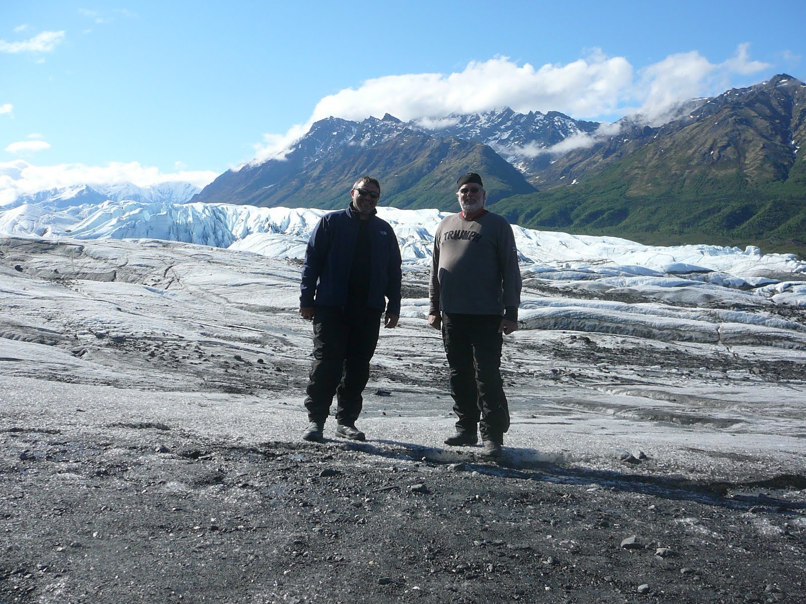
We paid our admission and road an additional 2 miles on a gravel road to the parking area near the glacier. We then hiked about 1/2 mile on an ice/gravel mixture foot path to get to the base of the glacier and then a little further to the actual ice portion of the Glacier. This was very interesting and somewhat difficult due to the wet, the soft ice and gravel mixture. When we walked to the glacier, the air was pretty cool. The glacier has such a cooling effect that it generates a strong wind down toward the base where we were standing. You could also see the water flowing from the underside of the ice carrying silt and small gravel. They warn you about how dangerous it can be with fast water flow and unstable ice. We soon found that we were walking on ice covered gravel and walking was somewhat difficult.

Road to the Glacier.
At the Glacier.
Bridge to the Glacier.
When we finished viewing the terminus of the glacier (that is the dirty end we were at) and walking back up the trail to the parking area, we talking to a couple of folks that work for the attraction and they were grooming the trail and they have to do this twice a day. They said with ice constantly melting and moving the rocks and gravel, the trail is constantly in need to grooming.

After we completed our hiking experience, we go back on the highway going to Glennallen and Tok.

The road continued to follow the riverside and we had some wonderful views of the white crowned peaks to the south toward Anchorage. We were very happy to view the mountains in their springtime color and still have snow on top. The road curved though mountain passes that had rivers of snow melt flowing through them that join the main river that flows to the sea.
Further on, the terrain opened up into a high plain with small marsh lakes and low rolling hills. In this area, there is very limited development. You are getting away from normal services and in some areas, electricity is not available.
This high plain was very large and covered with evergreens and low grass. Lots of marsh areas so travel is difficult. The high plain was at about 3200 feet and the air was clean, clear and cool. You could see for a long distance and the sky was clear but there were clouds ahead.

The road had a lot of undulations due to the soft soil and frost heaves. This made the ride somewhat like roller coaster but it went fine. Further on, the road was under construction with sections of gravel where we had to slow down our progress and fight a little dust, flying gravel and pot holes.
We were soon in Glennallen to refuel and and take a break. We then headed out of town toward Tok. We quickly ran into more road construction...dusty, wet, loose gravel with an escort vehicle.

This section of the road is under repair in several sections and these are tar and gravel repairs so a slowdown is required at each one.

This area is at the northern end of the Wrangell-St. Elias National Park so we had some wonderful views of snow capped peaks to the south and east for many miles. This park is the largest national park in the USA at 13.2 million acres and had 9 of the 16 highest peaks in the USA. Mt. Elias is the second tallest in the USA at 18,008 feet.
The ride twisted through several valleys at the base of these mountains that populate the edge of the park for an exciting, action packed ride with spectacular views. FUN, FUN,FUN!!!

As we neared Tok, the sky turned dark and ominous and just a few minutes to town, the skies opened up with and delivered a heavy drenching of large droplets of liquid sunshine.....rain!!!! Yuck.
We refueled in the rain and decided to stay the night here in the last stop in Alaska instead of pushing on in the rain. We quickly found a room at a reasonable rate and stopped for the evening.

Dinner was good at Fast Eddie's Restaurant with some red velvet cake for desert and a couple of beers to cap off the days ride.

We are off to Whitehorse, Yukon Territory in the morning.

Rode 275 miles today. Great time at the Glacier and riding next to the mountains with fantastic views.

More tomorrow.

Mike