Back on the road once again at Palmer, Ak. Had a quick breakfast at the hotel and got some gas and headed out on the Glenn Highway to the northeast with our goal of getting to Tok just before the border with Canada.
 As we refueled, we noticed that the mountains to the south that had cloud cover yesterday, were now free of clouds and really impressive with a mantel of bright white snow.
 Glenn Highway follows the Matanuska River. The road climbed quickly to over 2100 feet elevation and was a lot of fun to ride. The river is not very deep but it is very wide, fast flowing and silt filled. From what I am told, if the river is tan in color, it is from the underside of a glacier and if the stream is blue-green or clear, the water is from snow melt.
 About 85 miles us the road from Palmer, we found the entrance to the Matanuska Glacier and took the turn so that we could make the walk to the glacier. The road is gravel and it made river crossing on a bridge. See the pictures below.
 We paid our admission and road an additional 2 miles on a gravel road to the parking area near the glacier. We then hiked about 1/2 mile on an ice/gravel mixture foot path to get to the base of the glacier and then a little further to the actual ice portion of the Glacier. This was very interesting and somewhat difficult due to the wet, the soft ice and gravel mixture. When we walked to the glacier, the air was pretty cool. The glacier has such a cooling effect that it generates a strong wind down toward the base where we were standing. You could also see the water flowing from the underside of the ice carrying silt and small gravel. They warn you about how dangerous it can be with fast water flow and unstable ice. We soon found that we were walking on ice covered gravel and walking was somewhat difficult.
Road to the Glacier.
 At the Glacier.
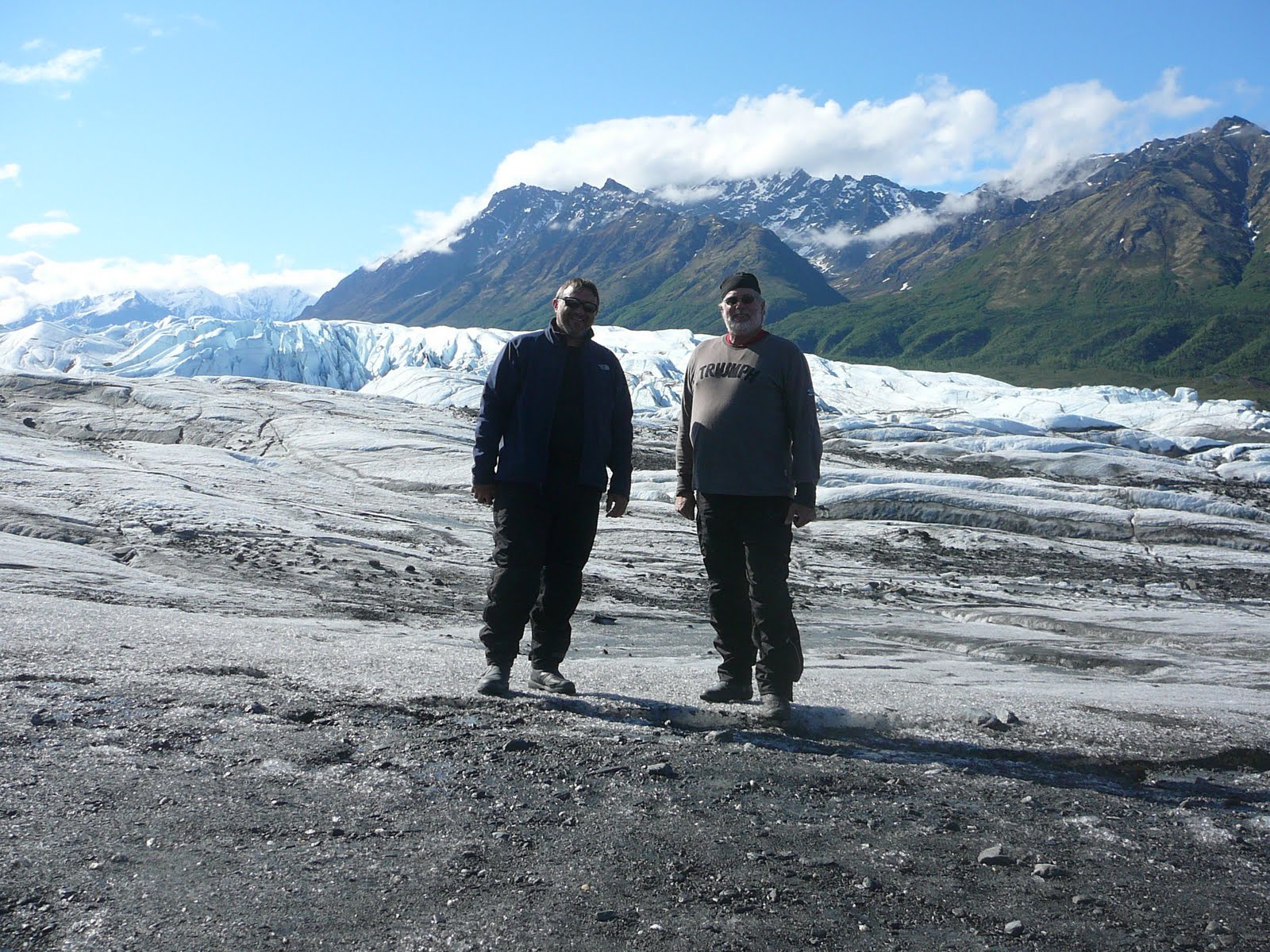

 Bridge to the Glacier.
 When we finished viewing the terminus of the glacier (that is the dirty end we were at) and walking back up the trail to the parking area, we talking to a couple of folks that work for the attraction and they were grooming the trail and they have to do this twice a day. They said with ice constantly melting and moving the rocks and gravel, the trail is constantly in need to grooming.
After we completed our hiking experience, we go back on the highway going to Glennallen and Tok.
The road continued to follow the riverside and we had some wonderful views of the white crowned peaks to the south toward Anchorage. We were very happy to view the mountains in their springtime color and still have snow on top. The road curved though mountain passes that had rivers of snow melt flowing through them that join the main river that flows to the sea.
 Further on, the terrain opened up into a high plain with small marsh lakes and low rolling hills. In this area, there is very limited development. You are getting away from normal services and in some areas, electricity is not available.
 This high plain was very large and covered with evergreens and low grass. Lots of marsh areas so travel is difficult. The high plain was at about 3200 feet and the air was clean, clear and cool. You could see for a long distance and the sky was clear but there were clouds ahead.
The road had a lot of undulations due to the soft soil and frost heaves. This made the ride somewhat like roller coaster but it went fine. Further on, the road was under construction with sections of gravel where we had to slow down our progress and fight a little dust, flying gravel and pot holes.
 We were soon in Glennallen to refuel and and take a break. We then headed out of town toward Tok. We quickly ran into more road construction...dusty, wet, loose gravel with an escort vehicle.
This section of the road is under repair in several sections and these are tar and gravel repairs so a slowdown is required at each one.
This area is at the northern end of the Wrangell-St. Elias National Park so we had some wonderful views of snow capped peaks to the south and east for many miles. This park is the largest national park in the USA at 13.2 million acres and had 9 of the 16 highest peaks in the USA. Mt. Elias is the second tallest in the USA at 18,008 feet.
 The ride twisted through several valleys at the base of these mountains that populate the edge of the park for an exciting, action packed ride with spectacular views. FUN, FUN,FUN!!!
As we neared Tok, the sky turned dark and ominous and just a few minutes to town, the skies opened up with and delivered a heavy drenching of large droplets of liquid sunshine.....rain!!!! Yuck.
 We refueled in the rain and decided to stay the night here in the last stop in Alaska instead of pushing on in the rain. We quickly found a room at a reasonable rate and stopped for the evening.
Dinner was good at Fast Eddie's Restaurant with some red velvet cake for desert and a couple of beers to cap off the days ride.
We are off to Whitehorse, Yukon Territory in the morning.
Rode 275 miles today. Great time at the Glacier and riding next to the mountains with fantastic views.
More tomorrow.
Mike
No comments:
Post a Comment